LOCATION

INDUSTRIAL-ZONED
The site is situated within a 30-mile radius of New York City, specifically near CSA’s midtown center, which boasts a $2.2 trillion GDP and serves a population of 21.9 million residents.
“...potential for quicker deliveries (inbound and outbound), less tolls/road taxes, lower freight rates...”
CONGERS, NEW YORK
NYC IS WITHIN EASY REACH
NYC IS WITHIN EASY REACH
Located just west of the Hudson River, this site is strategically positioned to address critical supply chain challenges.
NYC IS WITHIN EASY REACH
NYC IS WITHIN EASY REACH
NYC IS WITHIN EASY REACH
The site also offers less congested routing options by road, air, sea, and rail to connect efficiently with the rest of the US and Canada.
ROUGHLY 65%
NYC IS WITHIN EASY REACH
ROUGHLY 65%
Both the $27.4 trillion US GDP market and the Canadian $2.1 trillion CAD$ GDP are located within 1000 miles of this address.

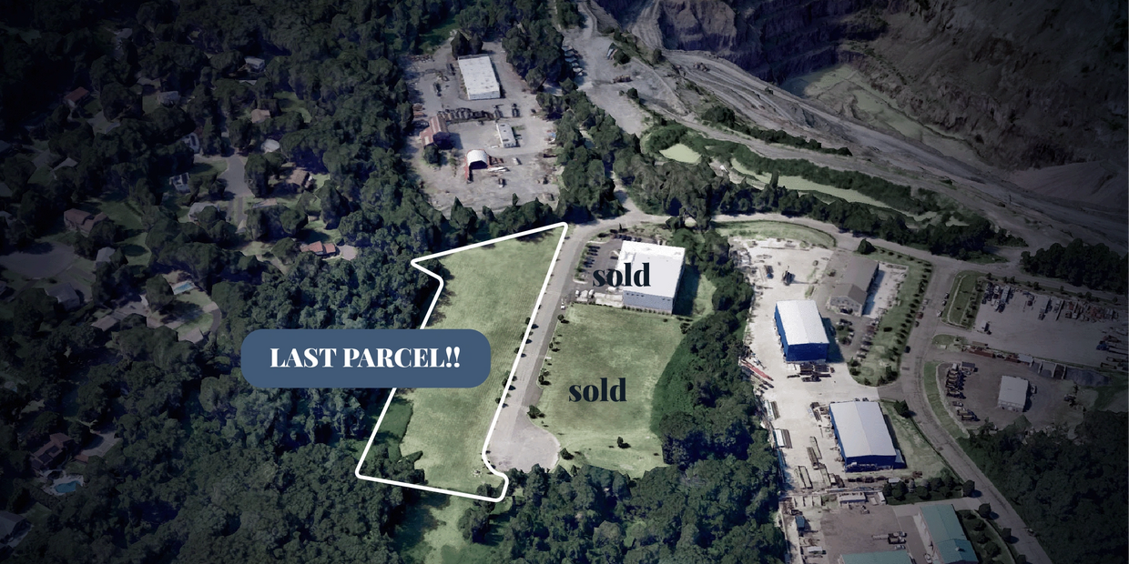
• The entire property is located on the west side of Landmark Drive.
• It features approximately 750 feet of street frontage along the public roadway.
• This is the last parcel available at 525-555 Landmark Drive, Congers NY 10920.
Industrial site features

SITE FLEXIBILITY
NOT JUST 'VACANT LAND'
SITE FLEXIBILITY
This is a unique property located in Clarkstown, Rockland County, featuring an 'M' zoning designation and exhibiting high land-use efficiency.

SITE LOCALE
NOT JUST 'VACANT LAND'
SITE FLEXIBILITY
In a low-congestion vicinity, you will find an area with an exceptionally safe environment and a low-crime rating.

SITE CONDITIONS
NOT JUST 'VACANT LAND'
NOT JUST 'VACANT LAND'
Numerous essential features have been designed, approved, implemented, and included.

NOT JUST 'VACANT LAND'
NOT JUST 'VACANT LAND'
NOT JUST 'VACANT LAND'
This site represents a significant industrial development that is progressing well towards a build-to-suit application.
Site flexibility
1. CLUSTER DEVELOPMENT
The original 10+ acre subdivision included an extension of Landmark Drive, which serves as a public (Town) roadway. From the subdivision’s initial six parcels, two have already been sold—one has been fully built out, while the second is currently under construction. The remaining four parcels, located on the entire west side of Landmark Drive, are now available for sale as a single contiguous group.
2. SITE APPROVALS
The cluster concept enhances the Town’s Planning Board's ability to oversee the comprehensive review of the entire subdivision. This approach allows each parcel owner to create plans tailored to their specific objectives, benefiting from a variety of waivers and established ‘bulk’ site provisions applicable to the whole subdivision. As a result, this not only promotes maximum design efficiencies but also streamlines the review process for individual parcel site plans.
3. SITE ENGINEERING
Significant engineering work has been completed, reviewed, and approved for the originally proposed projects in the subdivision. If any new project aligns with the subdivision’s prior engineering approvals, parcel owners advance further in the approval and permit processes for their ‘build to suit’ applications. This alignment can greatly decrease both the process time and the associated carrying costs of a project.
4. EFFICIENT SITE LAND USE
The cluster subdivision plan enabled LANDMARK to design site plans that can achieve effective net floor areas, reaching ratios of approximately 70% of the available land area. In contrast, an analysis of various recent industrial development projects within the NYC metropolitan area reveals that the approved usable floor area of industrial parcels typically ranges between 30% to 50% of a parcel’s net land area. This discrepancy is primarily due to factors such as lot irregularities, required setbacks, wetland restrictions, interior drive lanes, stormwater basins, buffers, and other property features that limit optimal land use. For LANDMARK, achieving a higher land use ratio not only enhances investment returns but also lowers the ongoing maintenance costs associated with areas that are not available for development.
5. SITE DEVELOPMENTS
To facilitate the construction of the first parcel in the Park, various infrastructure components were meticulously designed, approved, and constructed. These elements are now fully implemented and ready to support all future developments within the Park. Stay tuned for more updates on this topic.
Landmark City: About Landmark NY
I want to receive the detailed brochure.
Legal Notice This website collects minimal personal data, such as name and email address, when voluntarily submitted through contact or download forms. This information is used solely for communication related to Landmark Corporate Park and is not shared with third parties. By using this site, you agree to this privacy practice and to use this website for informational purposes only. All content, including text, images, and downloads, is the property of Landmark Corporate Park and may not be reused without written permission. We reserve the right to update or modify this website or its contents at any time without prior notice.
Credits: Icons by various authors from Flaticon | Map data ©2024 Google – Image ©2024 Maxar Technologies | Design by Diagre Studio
Copyright © 2025 Landmark NY - All Rights Reserved